Severe storms with intense tornadoes possible in Central US through Monday
Severe Storms with Intense Tornadoes Possible in Central US Through Monday
Severe storms with intense tornadoes possible – The weather pattern over the central United States has shifted dramatically, transitioning from a relatively calm May to a period of heightened storm activity. A sequence of powerful thunderstorms is anticipated to sweep across the Plains and Midwest, extending into Tuesday, with the potential for devastating tornadoes classified as EF3 or stronger. These storms will also bring large hail, damaging winds, and torrential rainfall, targeting regions historically prone to fierce springtime weather. This change is notable as it follows a period of minimal severe weather activity, attributed to a jet stream configuration that previously limited widespread storm development.
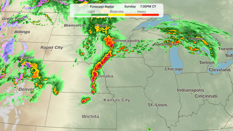
Sunday: Tornado Threat Intensifies
Sunday marks the beginning of the storm surge, with thunderstorms rapidly forming in the afternoon across Nebraska and southeastern South Dakota. These developing systems are expected to generate substantial hail and a heightened risk of tornadoes. The National Weather Service has already issued two tornado watches for the central US, covering eastern Nebraska, southeast South Dakota, northern Kansas, and western Iowa. Cities like Omaha, Lincoln, and Sioux City are within the zone of greatest concern. Over three million residents are under threat from these severe weather conditions.
“The same system that will bring dangerous tornadoes to the Central Plains and Midwest will also create very dry and windy conditions in the Southern High Plains,” the National Weather Service states in its forecast summary.
The storm system will produce a line of thunderstorms later in the evening, increasing the likelihood of winds exceeding 80 mph. While the morning’s cloud cover may influence afternoon storm intensity, areas where Sunday night’s storms linger will experience reduced energy for the subsequent evening, potentially altering the tornado threat zones. This dynamic underscores the complexity of predicting severe weather, as morning conditions play a crucial role in determining the afternoon’s risk profile.
Monday: Widespread Storm Outbreak
Monday is poised to be the peak of the storm activity, as a major surge in jet stream energy converges with ample moisture in the Plains. This interaction is expected to fuel widespread severe thunderstorms, with supercell thunderstorms likely forming in the afternoon. These cells will pose a significant tornado risk, with some storms potentially producing EF2 or stronger tornadoes. The central and eastern regions of Kansas, along with southeastern Nebraska and northwestern Missouri, are highlighted as areas of critical concern.
As the day progresses, damaging winds will emerge as the primary threat, alongside large hail. The timing of the storms will depend on how morning cloud cover interacts with the ongoing atmospheric conditions. If the morning remains dry, the afternoon’s storm activity could intensify, leading to more severe outcomes. Conversely, persistent cloud cover might dampen the intensity, shifting the focus to localized extremes rather than widespread damage.
Tuesday: Shift in Storm Dynamics
By Tuesday, the focus of the storm system will move eastward, with thunderstorms likely to persist from northern Texas through to Michigan. The potential for strong to severe storms will rise during the afternoon, though the tornado threat is expected to wane as a cold front becomes the dominant factor in storm development. This transition will reduce the likelihood of tornadoes but increase the risk of damaging winds and hail.
The Southern High Plains face a different challenge on Sunday and Monday, with a level 3 fire danger warning issued for the region. This classification signifies an extremely critical risk, as dry fuels combined with gusty winds and low humidity will allow fires to spread rapidly once ignited. Areas from southwestern Kansas to the Texas Panhandle and northeastern New Mexico are under the highest fire threat, while a level 2 danger spans a broader region, encompassing much of New Mexico.
While the tornado threat diminishes by Tuesday, the lingering effects of the storm system will still impact weather conditions. The convergence of dry air and strong winds will create an environment conducive to wildfires, even as thunderstorms shift their focus. This dual threat highlights the interconnected nature of weather systems, where the same atmospheric forces that drive tornadoes can also contribute to fire hazards.
The prolonged dryness in the Southern High Plains is a direct result of the storm system’s movement, which will leave behind high-pressure ridges and elevated temperatures. These conditions will persist, raising the risk of wildfires into the following days. The National Weather Service emphasizes that any fire that starts in these regions could escalate quickly due to the combination of wind speeds, fuel dryness, and low humidity levels.
As the storm outbreak continues, meteorologists are closely monitoring the interplay between moisture levels and temperature gradients. The potential for EF3 tornadoes remains a focal point, with the Midwest and Plains experiencing a surge in activity that could rival the most dangerous storm events of the season. Residents in these areas are urged to stay alert, as the intensity of the weather system may lead to unpredictable outcomes.
Despite the challenges, the storm system is expected to bring much-needed precipitation to certain regions, alleviating drought conditions. However, this relief will come at the expense of increased fire risk in the Southwest. The interplay between rainfall in the central US and dryness in the Southern High Plains illustrates the broader impact of atmospheric patterns on regional climates.
With the storm threat spreading across the central US, the National Weather Service continues to provide updates on the evolving conditions. The dynamic nature of this weather event underscores the importance of real-time monitoring and timely warnings to prepare for both tornadoes and wildfires. As the atmosphere shifts, the severity of the impacts may vary, but the overall risk remains elevated for the next several days.
