
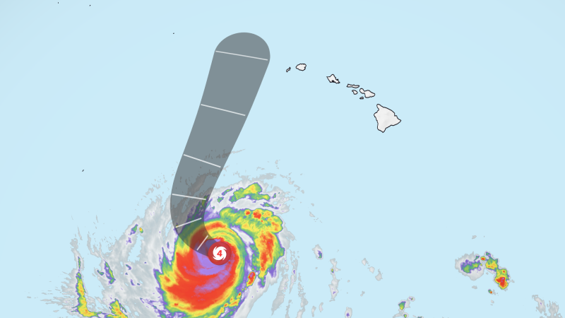
Hurricane Lowell Makes Final Turn Toward Hawaii
Sandego.net – After days locked beneath a stubborn upper-level pressure ridge, Hurricane Lowell makes final turn toward the Hawaiian Islands, swinging sharply northward out of its westward drift. Now a Category 3 hurricane with 120-mph sustained winds, the system is forecast to pass roughly 110 miles west of Niihau and 150 miles west of Kauai between late Monday night and Tuesday morning. Tropical storm warnings are already posted for both western islands, making this the third storm in just over three weeks to aim directly at the chain.
Why the Storm Changed Course
Lowell’s earlier westward crawl was dictated entirely by an invisible ceiling: a weak but persistent upper-level high-pressure zone that channeled the storm south of the islands and blocked any northward drift. Over the weekend, a cold-air trough descended from the north Pacific and collided with a nearby low-pressure area, eroding that ridge’s grip. Freed from the constraint, the steering flow rotated sharply and sent the hurricane on a northward trajectory that will drive its outer bands directly into the western slopes of the islands.
The National Hurricane Center notes that the system has been cycling between intensity categories — a normal oscillation for a major hurricane undergoing structural adjustments. At closest approach, forecasters expect near-Category 2 strength. Sustained winds above 39 mph are anticipated within the next 36 hours, though the strongest winds will remain largely offshore. The islands’ rugged topography, however, will amplify the threat: mountain peaks and steep slopes could experience gusts reaching hurricane force as terrain accelerates the flow.
What Hawaii Should Expect
The projected track draws an unavoidable comparison to Hurricane Iniki of 1992, which struck Kauai as a Category 4 hurricane and remains the most destructive storm in Hawaiian history. That parallel, while visually striking, ends at the coastline. Hurricane Lowell’s final turn will keep its center well offshore, sparing the islands the catastrophic direct-impact scenario Iniki delivered. The danger this time comes from the periphery: monstrous surf, torrential rain, and wind-driven flooding.
Hawaii Governor Josh Green declared a state of emergency for the entire state on Thursday, unlocking state resources and authorizing activation of Hawaii National Guard units. Six high-water vehicles are being staged on Kauai to handle anticipated road inundation. The declaration signals that officials expect conditions severe enough to overwhelm routine emergency-response capacity.
Long-period swells generated by the storm are already reaching the islands, and a high surf advisory is in effect for south-facing shores. The National Weather Service in Honolulu warns that waves could crest at 14 feet through Sunday afternoon. For residents and visitors along exposed coastlines, that translates into dangerous rip currents, overtopping of seawalls, and erosion of beachfront infrastructure — hazards that do not require the storm’s center to be anywhere near land.
The storm’s moisture field will blanket the entire archipelago. Kauai, Niihau, and the Big Island face 6 to 8 inches of rain, with isolated totals exceeding 12 inches possible in localized pockets. Oahu, Molokai, Lanai, and Maui are forecast to receive 2 to 4 inches on average, though mountainous terrain on those islands could accumulate up to 8 inches. The National Hurricane Center has issued a specific warning for
“significant flash flooding and mudslides”
particularly in steep terrain where saturated soils lose cohesion rapidly. Residents in drainages, ravines, and low-lying areas near stream channels should monitor conditions closely and be prepared to move to higher ground on short notice.
El Niño and a Warming Pacific
Lowell is not an isolated anomaly. El Niño conditions this year are warming sea-surface temperatures across the central Pacific and suppressing the upper-level wind shear that typically tears storms apart before they reach maturity. Layered atop a baseline ocean warming driven by long-term climate change, those factors are producing a Pacific basin more hospitable to tropical cyclone development than the historical norm. NOAA has projected an above-average central Pacific season, with five to thirteen cyclones expected from formation through decay. For Hawaii — an island chain sitting squarely in that corridor — the implication is clear: storms like this one will grow more frequent and more intense.
Frequently Asked Questions
When will Hurricane Lowell’s final turn bring the closest approach to Hawaii? Forecasters project the center will pass within roughly 110 miles west of Niihau and 150 miles west of Kauai between late Monday night and Tuesday morning.
Will the storm make direct landfall? No. The projected track keeps the eye well offshore. The primary threats are outer-band winds, extreme surf, and heavy rainfall rather than a direct-impact scenario.
How much rain should residents expect? Kauai, Niihau, and the Big Island face 6 to 8 inches, with isolated pockets exceeding 12 inches. Oahu, Molokai, Lanai, and Maui are forecast for 2 to 4 inches on average, up to 8 inches in elevated terrain.
What should I do before the storm arrives? Move vehicles out of low-lying areas, secure or bring in outdoor items, fill containers with water, and know your evacuation route. If you live near a drainage, ravine, or stream channel, be ready to move to higher ground on short notice.
Is the state of emergency still in effect? Governor Josh Green declared a state of emergency for all of Hawaii on Thursday, authorizing National Guard activation and staging of high-water vehicles on Kauai. Monitor official channels for updates on duration and scope.