
Unusually Strong Summer Storm Puts Northeast on High Alert
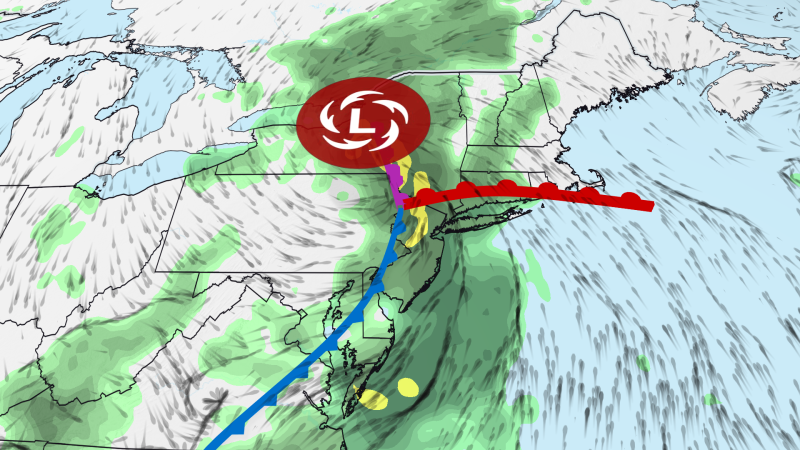
Sandego.net – Unusually strong summer storm puts New York City at the center of a developing weather crisis. An exceptionally powerful atmospheric system is currently sweeping through the northeastern United States, creating significant concerns for millions of residents across the region. The New York City metropolitan area sits at the heart of this situation, with meteorologists warning that residents could experience up to an entire month’s precipitation falling within just several days. This remarkable storm originated from a pocket of atmospheric energy that triggered severe thunderstorm activity across portions of the Great Lakes and Ohio Valley on Monday.
While powerful wind gusts represent the primary immediate threat—capable of knocking down trees and disrupting electrical power—meteorologists have also indicated that isolated tornadoes remain possible. One particularly destructive tornado touched down in northeast Wisconsin on Monday afternoon, demonstrating the storm’s potential for violence. According to weather forecasts, this system will begin its journey into the Northeast on Tuesday, where it will dramatically intensify and slow its forward movement considerably.
Historical Storm Strength in Midsummer
What makes this particular weather event especially noteworthy is its intensity relative to the season. When the storm reaches central New York on Wednesday, its strength will more closely resemble systems typically observed during October, November, or December rather than late July. Meteorologists explain that summer storms generally possess less power than their winter counterparts because the jet stream contributes less energy to intensification during warmer months.
Unusually strong summer storm puts additional pressure on regional infrastructure as it draws moisture from enhanced atmospheric pipelines originating in both the Atlantic Ocean and the Gulf of Mexico. The water vapor content within this air mass is projected to reach levels substantially exceeding normal expectations, even accounting for midsummer’s typically humid conditions. These contrasting atmospheric elements will collide, generating multiple cycles of heavy rainfall and thunderstorm development throughout the northeastern region.
Flood Risk Timeline and Regional Impacts
The New York Tri-state corridor, extending from northern New Jersey through western Connecticut, faces the greatest probability of flooding rainfall during Tuesday and Tuesday evening. However, a more localized threat extends across most other portions of the Northeast. Morning precipitation moving from eastern New York into Pennsylvania will likely be followed by additional rainfall episodes throughout the afternoon and evening hours.
Intense storms within this system could generate rainfall rates reaching as high as two inches per hour. Urban environments and areas with inadequate drainage infrastructure face the most significant flooding concerns. Some locations may experience impacts escalating to more serious levels, mirroring events that have occurred multiple times across the United States during July, including a notable incident in New York City on July 18 according to National Weather Service data.
Flash flooding remains one of the most lethal weather hazards, particularly within urban settings. Nearly five years ago, Hurricane Ida caused dozens of fatalities across the Northeast when it deposited between seven and ten inches of rain across a similar geographic corridor that currently faces renewed threat.
Extended Forecast and Travel Considerations
Further southward, severe thunderstorms present concerns on Tuesday stretching from the Washington, DC area through North Carolina. Wind damage represents the primary threat from any storms that develop in this region. The most extensive flash flood risk will gradually shift northward on Wednesday into southern New England, encompassing Boston and Hartford, though New York City will continue facing elevated risk.
Heavy rainfall is expected to persist across this area as Wednesday begins. Flash flooding may develop as one or more narrow bands of intense precipitation spread northeastward through the afternoon hours. New storm cells could also form behind this primary rain band. The National Weather Service office in Boston indicated that at least scattered flash flooding impacts remain possible, particularly in urban zones and areas with poor drainage infrastructure.
Travel disruptions are anticipated at airports and on roadways throughout the region. Pockets of heavy rainfall may continue in portions of the Northeast through Thursday, though meteorologists caution that specific flooding concerns cannot yet be precisely identified. Much of the northeastern flood threat zone is expected to accumulate between one and four inches of rainfall through Thursday, with some localized areas potentially receiving six inches or more.
Frequently Asked Questions
When will the unusually strong summer storm puts peak impact on New York City? The most intense period for New York City is expected on Wednesday, when the storm reaches central New York with strength comparable to fall weather systems.
How much rainfall should residents expect? Most areas will receive between one and four inches of rainfall through Thursday, with some localized areas potentially receiving six inches or more.
What are the main hazards from this storm? The primary hazards include flash flooding in urban areas, powerful wind gusts capable of downing trees, and isolated tornadoes, particularly in the early stages of the system.
How does this compare to Hurricane Ida? While Hurricane Ida deposited seven to ten inches of rain and caused dozens of fatalities nearly five years ago, this current system is expected to produce less total rainfall but still poses significant flash flood risks to similar geographic corridors.
For the latest updates on this weather event, visit CNN Weather for real-time tracking and forecasts.