
Atlantic Basin Stirs as Cristobal Emerges Amid El Niño’s Grip
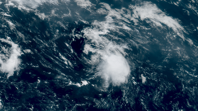
Sandego.net – The Atlantic hurricane basin has finally begun to shake off weeks of dormancy, with Tropical Storm Cristobal making its appearance in the northern Atlantic waters. This development comes after the powerful El Niño climate pattern had been suppressing storm formation, effectively keeping the seasonal activity in check. The National Hurricane Center confirmed that Cristobal achieved tropical storm status late Wednesday morning, bringing with it sustained winds reaching 45 miles per hour. What makes Cristobal’s emergence particularly noteworthy is how precarious its formation appeared. Earlier in the same day, meteorologists had assigned only a coin-flip probability to the system’s potential for development. Now, the storm exists as a tangible threat, though forecasters expect it to remain relatively brief over open waters. Cristobal is anticipated to move into colder ocean temperatures and potentially dissipate by Thursday afternoon, posing no direct danger to populated areas.
Multiple Systems in the Works
While Cristobal may be short-lived, it could soon have company. Meteorologists are tracking two distinct areas of potential development. The primary focus lies in the tropical Atlantic, where conditions present an eighty percent probability of producing at least a tropical depression by the end of the week. A secondary area positioned just to the east carries a forty percent chance of development over the coming days. The naming sequence continues steadily, with Dolly designated as the next tropical storm name should another system develop in the basin. Mid-August traditionally marks the transition into the Atlantic’s most productive period for storm formation. However, any systems attempting to develop now face considerable headwinds—literally. El Niño has established itself as a formidable obstacle, primarily through its creation of wind shear, a phenomenon that disrupts tropical cyclone development.
Understanding El Niño’s Hostile Conditions
Wind shear represents one of the most significant barriers to tropical storm formation and intensification. This atmospheric condition involves variations in wind speed or direction across different altitude levels within the atmosphere. When strong wind shear exists, it can prevent storms from organizing initially, inhibit their strengthening process, or even tear apart existing systems entirely. Currently, this disruptive force sits firmly positioned over what would normally be the Atlantic’s most active regions. The presence of wind shear in these critical areas aligns with numerous predictions forecasting a below-average hurricane season. The situation may worsen as El Niño continues to strengthen. Meteorologists anticipate the pattern could evolve into a potentially record-breaking Super El Niño over the coming months. Phil Klotzbach, a hurricane specialist at Colorado State University, noted that wind shear has recently reached record-strength levels in the Atlantic basin.
Season Performance and Historical Context
The Atlantic hurricane season has largely fulfilled expectations of subdued activity. Through August 11, the basin experienced its least active beginning since 2009. Only Arthur and Bertha had achieved tropical storm status before Cristobal’s arrival. Both systems developed along the Gulf Coast but struggled against persistent wind shear, which limited their intensification and overall impact. Cristobal represents a departure from this pattern, marking the first storm of the season to form away from the United States coastline. Standard Atlantic hurricane seasons typically produce at least three tropical storms by August 3 and four by August 15. The season also trails behind on hurricane development. The first hurricane normally emerges around August 11. In 2025, Hurricane Erin formed just days after this benchmark, while 2024 had already recorded two hurricanes by the same date.
Looking Ahead
The main development region—the area where most Atlantic storms originate—should normally experience heightened activity during mid-August. Warmer water temperatures and relaxed wind shear typically provide ideal conditions for tropical systems. El Niño has disrupted this pattern, maintaining stubborn wind shear despite the season’s natural progression. Computer forecast models suggest the potential system with high development chances could track toward the eastern Caribbean this weekend. This trajectory would expose the system to additional wind shear challenges. Meanwhile, the medium-probability area in the far eastern tropical Atlantic faces similar obstacles. The window from mid-August through mid-October remains the primary period for tropical storm and hurricane formation. While El Niño presents significant challenges, the season still has considerable time for systems to develop and potentially strengthen. Coastal communities and meteorologists alike will be watching closely to see whether any of the current candidates can overcome the atmospheric barriers standing in their way.
Related Reading
Frequently Asked Questions
What is Tropical Storm Cristobal forms in the Atlantic?
Tropical Storm Cristobal forms in the Atlantic is the main topic of this guide. The article explains the context, practical details, and next steps readers should understand.
Why does Tropical Storm Cristobal forms in the Atlantic matter?
Tropical Storm Cristobal forms in the Atlantic matters because readers are looking for a useful answer, not just a short summary. Good content should match search intent and help them decide what to do next.