Tropical Storm Watch Activated for Flood Risk in Texas and Louisiana
Sandego.net – Authorities have issued a tropical storm watch for coastal regions in Texas and Louisiana, signaling the potential for a system to develop into a short-lived tropical storm within the next 72 hours. The National Hurricane Center (NHC) has designated this system as Potential Tropical Cyclone One, a classification used to highlight areas where tropical storm conditions may emerge soon. While the storm’s exact trajectory remains uncertain, its impact on the Gulf Coast is already evident, with heavy rainfall triggering flash floods and endangering lives.
System’s Progress and Forecast
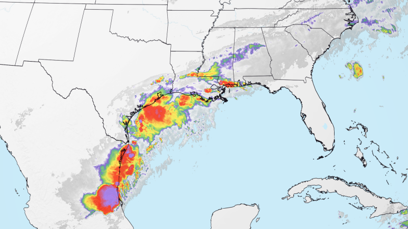
As of 11 a.m. ET, the storm’s center is located approximately 65 miles southwest of Corpus Christi, Texas. Meteorologists predict it will evolve into Tropical Storm Arthur by early Wednesday, potentially moving inland through extreme east Texas or southwest Louisiana by late Wednesday or early Thursday. The NHC warns that tropical-storm-force winds, reaching 40 mph or more, could affect areas from Sargent, Texas, to Fort Morgan, Louisiana. However, the most significant threat remains heavy precipitation, which has already saturated parts of the region.
Residents in Texas and Louisiana are bracing for prolonged rainfall, with flood watches in place for over 16 million people spanning from South Texas to central and southern Mississippi. The Weather Prediction Center has escalated the threat level to a Level 3 out of 4 for flash flooding across Texas, Louisiana, Mississippi, and Alabama. Some areas could receive up to 3 to 4 inches of rain per hour, while others may see an additional 4 to 8 inches over the next few days. In extreme cases, floodwaters could reach a foot in depth, creating life-threatening conditions.
Impact on Communities and Rescue Efforts
The system’s moisture has collided with a stalled weather front, leading to widespread flooding. In Bandera County, northwest of San Antonio, a tragic incident occurred on Monday when a woman was swept away by floodwaters and killed. Her vehicle was discovered several miles downstream, fully submerged, after she lost contact with rescuers. “Floating downstream at a high rate of speed and unable to exit her vehicle,” she reported to 911 before vanishing into the current, according to the sheriff’s office statement.
“She was in a vehicle that was rapidly being carried by floodwater, and we couldn’t reach her in time,” said the sheriff’s office. Authorities deployed swift water rescue teams to locate the missing woman, emphasizing the urgency of the situation.
In Houston, Texas, drivers faced perilous conditions as floodwaters reached their trailer hitches, with vehicles caught in the rising streams. Similarly, in Waco, Texas, roadways were washed away during Sunday night’s storms, forcing multiple rescues. The Texas Department of Transportation confirmed that several vehicles were stranded on Interstate 35, highlighting the severity of the flooding in urban and rural areas alike.
Travis County Judge Andy Brown reported that about 80 low water crossings were flooded by Monday morning, leaving drivers stranded. One individual was rescued after becoming stuck at a low water crossing, while others in Bexar County experienced similar emergencies. Bexar County Fire Marshal and Emergency Management Coordinator Chris Lopez noted that multiple water rescues were conducted, underscoring the scale of the crisis.
Neighbors in Williamson County also faced challenges, with responders assisting drivers at two separate low water crossings. County spokesperson Connie Odom described the situation as “highly dynamic,” with floodwaters continuously shifting and threatening new areas. In Shreveport, Louisiana, floodwater similarly stranded vehicles, though details of the specific incidents remain under investigation.
State Response and Disaster Declaration
Gov. Greg Abbott has taken decisive action by declaring a state of disaster for 101 counties, mobilizing emergency resources to combat the flooding. This declaration comes as the storm continues to test the region’s infrastructure and emergency preparedness. “We are witnessing conditions that could overwhelm even the most resilient systems,” Abbott stated in a press release, stressing the need for coordinated efforts to mitigate damage.
Across the Gulf states, the combination of heavy rainfall and stalled fronts has created a perfect storm for flooding. Areas such as Brownsville, Texas, and Lake Charles, Louisiana, are expected to see significant to life-threatening flash floods. The NHC warns that the system’s effects will persist through Thursday, with rainfall rates varying depending on location. While some regions may escape with moderate downpours, others are in for a more severe deluge, raising concerns about prolonged impact on communities.
Residents are advised to monitor updates from CNN Weather and local emergency services as the storm progresses. The NHC’s forecast indicates that Tropical Storm Arthur could bring torrential rains and gusty winds to the region, compounding the challenges posed by the existing floodwaters. “This is a situation where every hour matters,” said a meteorologist, highlighting the need for rapid response to prevent further casualties.
As the system moves inland, its influence will spread across Texas, Louisiana, and Mississippi, with the western Florida Panhandle also at risk. The potential for 4 to 8 inches of rain in southern and eastern Texas, coupled with the ongoing downpours, means that the region may face a prolonged period of flooding. Areas that have already seen 4 to 8 inches of rain, such as Caldwell, Texas, where the highest total was just over 9 inches by Tuesday morning, are under particular scrutiny.
Emergency crews are working tirelessly to rescue stranded individuals and manage floodwaters. In Waco, Texas, for instance, floodwaters caused roadways to be submerged, forcing swift action by rescue teams. “I have not seen flooding like that in Waco before,” remarked Texas Game Warden Capt. Matthew Kiel, noting that most low water crossings in McLennan County, where Waco is located, were overwhelmed. The same pattern has been observed in Milam, Williamson, and Burleson counties, where residents are navigating hazardous conditions.
With the threat of flash flooding intensifying, authorities urge residents to stay alert and take precautions. The NHC’s warning system is in place to guide communities through the crisis, but the real-time challenges of managing the floodwaters and rescuing individuals will determine the success of the response. As the storm progresses, the focus will remain on minimizing damage and ensuring public safety.
Overall, the situation underscores the vulnerability of the Gulf Coast to extreme weather events, especially when tropical systems interact with stalled fronts. While the potential for a tropical storm remains, the primary danger lies in the prolonged rainfall and its ability to saturate the land, creating conditions for catastrophic flooding. The response efforts by state officials and emergency teams will be critical in safeguarding lives and reducing the impact of this weather crisis on the region.